The Outward Bound Map & Compass Handbook
Reading along with compass in hand helps tremendously. I'm thick-skulled and literal-minded, so I've reread many of the book's explanations several times. I learn by doing, especially with props; words don't make much of an impression on me. I have taken a map and compass workshop here and there, but it's been a while. My best experience was on a NOLS trip through the Wind River Range in Wyoming in anticipation of my AT hike. Little did I realize that it is nearly impossible to get lost on the AT.
Reason and I had a compass on the PCT. We used it exactly three times. It was most helpful when we came across the icy Tahquitz range south of Idyllwild, CA and lost the trail. It was handy the second time around when we stopped for a break and Reason, perhaps being a bit under the influence, insisted I was headed the wrong way on the trail when we resumed hiking. I don't mind telling you that I enjoyed the compass's confirmation that I knew where I was going. The third time we used it, we came to an intersection of five trails just north of Mt. Hood. The unsigned PCT made a turn at the intersection that sent it south. Three thru-hikers, a German weekender, and a very large and excited Great Dane puppy argued about which way to go until we realized that the compass might solve the dilemma for us.
The CDT presents my first opportunity to get good and lost. With a handful of hikers attempting the trail each year, the path is not well-beaten. Only about 70% of the trail has actually been constructed, and some of that trail is little used and little maintained. I think even W would tell you that clearing brush from a trail is the difference between keeping a trail and losing it.
I read 2008 thru-hikers Cookie and Paul's account of following a cattle path well into the wrong canyon before they realized their mistake. It is a fact that there are more cows on the CDT than there are hikers.
Getting back to my cramming, I sat up and coughed at the OB Map & Compass Handbook's
Declination is the difference in direction between true north and magnetic north. Generally speaking, true north points to the North Pole and magnetic north is the direction the needle on the compass points. Magnetic north varies depending on the Earth's magnetic field at a given location. Magnetic north also apparently changes over time, but I don't know why.
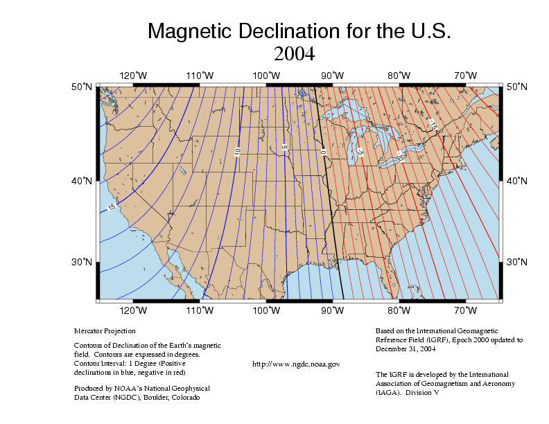
Declination in the United States varies from about 18 degrees west on the West Coast to about 16 degrees east on the East Coast. The problem is that the maps point to true north.
What this amounts to is that if you don't know the difference between true north and magnetic north, you might follow an erroneous compass bearing that will take you miles off course.
More practically, the wonderful Jonathan Ley maps upon which we are dependent don't note the declination. Neither do the Wolf CDTS guides. So what is the declination on the CDT?
I dunno, but I Googled for some declination charts of the US. I found this one and printed it out. It dates to 2004, so I hope the earth's magnetic field hasn't changed too dramatically since then. We'll just have to guess in the field, but it looks like we'll have to adjust for a declination of between about 9 and 16 degrees east. Which means we'll have to add the declination to the compass reading and subtract the declination from the map reading, depending on which reading we start with.
Hmm... I hope I got this right! Reason seems to have a good instinct for this sort of thing, not to mention a calmer disposition. Between the two of us I'm sure we'll make it to Canada one way or another.
Some of you may wonder why we aren't taking a GPS with us. My first answer is that, though I do enjoy the many benefits of technology, I can't wait to get away from the phone, the computer, the radio, the TV and all of those annoying blinking lights and beeps that drive me crazy. (Rant: why can't my stupid cell phone just die when it runs out of juice in the middle of the night instead of waking me up with its annoying chirps??? Why does the stupid wireless thingy need to proudly proclaim its existence with big bright light??? I don't want to hear or see any of it. As far as I am concerned, they can all just die.)
My second answer is that I'm excited about the mental challenge of getting myself from one place to another using a few simple tools and my head. If only I've got the logic of the compass right!!
My third answer is that I don't want to watch my GPS screen all day long following waypoints. I want to be aware of the landscape around me. I'm excited about really learning how the map relates to reality. My father used to study maps of the places he visited to the point that he no longer needed them when he arrived. He'd overhear other tourists wondering about the landscape and he'd proudly straighten them out.
I'm really excited about knowing where I am. Not only do I want to keep myself found, but I want to be more engaged with the place I'm visiting.
I remember images. I have an excellent visual memory which has served me extremely well in the art field. This could be Team Creason's last long distance hike for many years, and I want to know and remember the mountains and streams we will be living in for the next five months.
Update: This wonderful compass tutorial created by Kjetil Kjernsmo is very helpful.


No comments:
Post a Comment